April 15-18, 2021
About 20 years ago, my husband, two daughters, and I set an all-time family record: we visited five national parks in one day. We started the morning at the Grand Canyon, then did Zion, Bryce, Arches, and Capitol Reef. I must say, this is less than an ideal way to visit these parks but we must do what we must do.
This past weekend, my hiking/biking buddy and friend Cathy and I blew that record out of the water in a much more agreeable way, not with national parks, but with Palmetto Trails. We hiked the Blackstock Battlefield and Glenn Springs passages on Thursday, hiked the Croft passage on Friday, and then on Saturday we hiked the Cedar Springs passage, biked Hub City, and hiked the USC-Upstate passage. Finally, on Sunday before heading home we biked the first five miles of the Peach Country passage. And on the way home, just for kicks I hiked Lynch’s Woods. Hiking and biking seven and a half passages in four days in the beautiful Piedmont…that’s my kind of record! Here’s our story in all its gory detail.
Blackstock Battlefield. This was the first stop on our adventure. The 1.6 mile loop was rated as moderate in difficulty, although we didn’t find it hard at all. This area was the site of a Revolutionary battle between the forces of General Thomas Sumter and the British commander Banastre Tarleton. Tarleton had been ordered to give up his fruitless search for Francis Marion and deal with Sumter, whose men were causing trouble for the British in the upcountry. Because of intel from Mary Dillard (check out this fascinating story of her bravery: http://legendsofthefamily.blogspot.com/2017/08/mary-ramage-dillard-wife-mother-and.html), Sumter was ready and whupped up on Tarleton, earning Sumter the moniker “the Fighting Gamecock.” Go, Cocks!

As intriguing as this history was, I was completely enthralled with the plant life around Blackstock. My Seek app helped me identify Lyreleaf sage (not blooming, but handsome nonetheless), Wild azalea (slightly past prime), cheerful Yellow stargrass, dainty but unpronounceable Tainturier’s Chervil, Painted buckeye (guess what their seeds look like?), Green-and-gold (guess what colors?), Round-lobed hepatica (hate that we missed the flowers, but the leaves are beautiful in and of themselves), sweet little Rue anemone, Little Brown Jug with its namesake flower hidden under the leaf litter, and my favorite: Bashful wakerobin trillium. How can you not love a plant named Bashful wakerobin? I get why botanists rely on the scientific nomenclature of plants, but I much prefer the common names. I will admit, though, that I giggle every time I see the Latin name for butterfly pea.

Lyreleaf sage 
Wild azalea 
Yellow stargrass 
Tainturier’s Chervil 
Painted buckeye 
Round-lobed hepatica 
Rue anemone 
Little Brown Jug 
Bashful wakerobin
Blackstock Battlefield parking address: M5HQ+RF Enoree, SC, parking at kiosk
Glenn Springs. After dropping off a car at the northern trailhead, we drove to the southern trailhead to start our hike. The only problem was, there was nowhere to park. We drove up and down the street but there was absolutely no place to leave my truck. Luckily Cathy is much more assertive than me and decided to go ask the homeowner of the property nearest the trailhead. The man was very gracious and kindly allowed us to park on his side yard.

Upon strapping on our packs, we discovered just how thoughtful Cathy’s husband was. He had once again hidden a heavy canned ham in her pack so that she could build up her strength! What a guy!

The first part of the trail took us beside a field with nearby goats. We entertained them with our goat-speak, but apparently they didn’t recognize our dialect. Onward through the forest we went, remembering too late that it was turkey hunting season and we weren’t wearing orange. Luckily, the hunters were taking the day off. Coming down a hillside, we smelled an alluring scent. We traced the smell to a bush I later identified as Japanese silverberry. A highly aggressive invasive bush, we were to find these all through the forest and in fact they surrounded our campsite at Croft.

At Deer Springs Road, we almost lost the trail and our patience. The Glenn Springs passage does not have an Avenza offline map for us to navigate with, so we had to make do with a printed map. We finally spied the trail in the woods across the street and continued on our way to a power line. Not spotting any trail markers, we continued on the well-traveled power line down one hill and up another until our trail started to peter out and we (meaning I) started to question our (meaning my) navigation skills. We backtracked to where the trail came to the power line and took a good long look around. Finally, across the field, almost hidden in the tall grasses, we saw the trail marker. This was the first of many “hiccups.”

Our next hiccup occurred when we took what must have been the spur trail to the trailhead called the Mary Browning Pass. This hiccup was fortuitous. A most beautiful kiosk awaited us, thanks to the family of Mary Browning. This was an interesting intersection, with the Calvary Episcopal Church on one side, the old Glenn Springs Post Office on the other, and tucked back behind it, the Old Stone Church with its Southern Gothic architecture. We rested on the stone benches of the Episcopal church under clouds of Banksia roses. Heavenly.


We continued up Boys Home Road, past beautiful fields and one home guarded by about five free-roaming aggressive dogs. We did our best to dog-speak them into friendliness, and although they never responded in kind, they did let us pass without tasting us. Soon enough, we were back at our car on Foster Mill Circle. To reward our feet for carrying us nine miles, we stopped at a creek and dipped our tired toes in the cool water. Ahhhh…

Glenn Springs parking addresses: Northern trailhead V535+4C Pauline, SC (park on side of dirt road); Southern trailhead Q5P6+3G Pauline, SC (575 Stagecoach Rd, Pauline, SC) Ask owner’s permission to park in yard.
Croft. It was after 5:00 when we finally arrived at our campground at Croft State Park. The office was closed, so we found our own way to our reserved primitive tent site #2, clearly marked with a “2” etched into a wooden post. We were all settled in with everything carried down to our site and a campfire blazing when the campground host came around. He informed us that we were not in site #2, but were actually in site #7 and would have to move in the morning. Apparently they had renumbered the sites and someone had removed the paper over the post that had said 7. Our new site was a quarter mile down the hill. So much for an early start to our hike the next morning.

Bright and early, we set off to move. Well, maybe not bright. There may have been a few nasty words scattered in the wind. We had already toted our cots and tent—fully set up—down to site #2 when the host arrived. He very graciously helped us move our heavier items in his truck, causing us to hastily gather up all those nasty words and quietly dispose of them.

Croft State Park has an interesting history, one that tends to keep this wanderer on the path. In the late ‘30s and early ‘40s, the federal government moved farmers off this land through eminent domain to build an Army training camp. Camp Croft had large ranges set up for training in the use of mortar, grenades, and other instruments of destruction. About a quarter million US Infantry soldiers were trained here, and nearly 1000 German POWs were housed here as well. When the war was over, Croft State Park was created in its place. Numerous signs reminded trail users to stay on the path as munitions are still being found in the area.

We decided to hike this passage from north to south. The Advance America Bridge crossing Fairforest Creek near the southern end had been washed away, and we hoped to be able to ford the creek. However, we thought it prudent to do so at the end of our hike rather than the beginning, what with wet shoes and all. This turned out to be a wise decision.
Our trailhead had a nice parking lot right behind the SC School for the Deaf and Blind. We immediately set off in the wrong direction. Oops. We were on the Cedar Springs passage. Fortunately, we realized our mistake quickly and turned around, but not before I rescued a chopped up mylar balloon (my second of this trip).
Back at the parking lot, we went up the hill to the left. This is a case where right is wrong. We were soon in the woods and enjoying the trail beside cheerful little Kelsey Creek. At one point, I tried to convince Cathy that the trail took us over the remnants of an iron bridge, but she was too smart for me.

In addition to this bridge, we saw further evidence of the farmers who had been displaced by the Army camp: a stone wall and a house site with rusted paraphernalia scattered around. However, we made sure to stick to the trail to view these. Mostly.


A species of plant caught my fancy on this trail. At first, I only spotted one but before long they were everywhere: Wild comfrey, also called Blue houndstongue. Apparently this plant is good for wounds and other ailments of the skin. Luckily, we didn’t have to try it out.


We didn’t see many animals on this trail. There was one brave box turtle by the trail, but I forgot to lift it up to see if it was a he (concave plastron) or a she (flat plastron). Since this was an equestrian trail, we did pass a number of horseback riders. One friendly couple stopped to chat and pretended amazement when I called the name of the horse. Boy, he was a nice horse!


We were amazed by the height of the SCETV antenna that we passed. It made me queasy to even think about the workers who had to build or maintain this tower.

My favorite part of the trail, however, came near the end when we finally came to Fairforest Creek. Cathy’s car was one mile on the other side. My truck was 13 miles back. Forward was our only choice. From a distance, the creek didn’t look too imposing. Up close, it became apparent that with the force of the water, slick rocks, and deep sections, this would be no easy crossing. After scouting upstream a bit and finding no better place, we went back to where we had started.
Being the taller and less bright of the two, I decided to try it out first. I secured all my valuables in Ziploc bags, tucked them safely in my pack, and stepped in. The water felt good on my tired feet and my trail runner shoes did a good job of gripping the rocks. I was soon in over my knees. I struggled to find good footing on the moss-covered rocks, trying to avoid getting my feet stuck between the proverbial rock and a hard place. The rushing water threatened to push my trekking poles out from under me and at one point I had to stretch my legs more than a yard apart to reach a safe spot. It was about here that I realized that this was not the smartest thing I had ever done in my life. Soon enough, however, I was safely on the other side.
But what about Cathy? She was shorter (and smarter) and would not be able to cross where I did. With the help of a bystander (who I’m sure was taping my crossing for a You Tube video he would entitle, “Hey, Y’all, Watch This”) we found a much safer spot downstream a ways. Although deep, the bottom was sandy and the water less swift. Cathy made it across without a hitch. Lesson learned: next time Cathy goes first.

The safe crossing spot 
The not-safe crossing spot 
The orange line marks my crossing!
After 14 miles of hiking and one exciting creek crossing, we were done.
Croft parking addresses: Southern trailhead, V535+4C Pauline, SC (park on side of dirt road); Paved parking lot at northern trailhead, W45G+FJ Spartanburg, SC
Cedar Springs. This was a short one. Actually, at 1.1 miles it is the shortest passage of the Palmetto Trail. It is also most likely the least known of the passages, seeing as how it’s not yet listed on the palmettoconservation.org website. We decided to extend our hike into the Hub City Connector a bit, parking one vehicle at the southern end of the Mary Black Rail Trail for a total of 2.7 miles. Just enough to stretch our legs before biking Hub City.

The Cedar Springs trail took us around the perimeter of the campus of the SC School for the Deaf and Blind. Starting at the southern end, we passed a therapeutic riding facility named HALTER: Handicapped Athletes Learning To Enjoy Riding. I do love me a good acronym! HALTER had an interesting riding trail through the woods and gorgeous green pastures. If I ignored the highway on my left, I would have thought I was in the beautiful countryside.

The Cedar Springs passage technically ended at the edge of their campus, but we kept on going. Although not as scenic as a woods walk, we did pass by some interesting places. Before we knew it, we were at the Mary Black Rail Trail where our bikes were waiting for the next part of our adventure.


Cedar Springs parking addresses: Paved parking lot at the southern trailhead, W45G+FJ Spartanburg, SC; Northern trailhead (Small paved parking lot at the southern end of the Mary Black Rail Trail) W4J3+QV Spartanburg, SC
Hub City Connector. This passage tested our navigational skills and our patience. I give us (meaning me) a D- on both. We got off to a good start on the two-mile Mary Black Rail Trail. This former railroad line was actually a very appropriate place to start, as the “Hub City” nickname for Spartanburg came about due to the many rail lines that came into the city, making it look like the hub of a wheel. The rail trail has many interesting features, including a skate park, a dog park, and a mountain bike track.

But then it ended, and we didn’t know which way to go. There is no Avenza map with its friendly blue dot showing you where you are on the Hub City Connector. The pdf map downloaded from palmettoconservation.org was lacking in detail and hard to read on my cell phone. Luckily, I had a printed copy. Unluckily, I didn’t print it in color, making it difficult to read as well. The map looks fairly straightforward. On the ground, not so much.
There were quite a few hiccups going through the city and more than a few times we stopped to ask passersby how the heck to get to where we needed to be. I will say that Spartans (Spartanburgers?) (Spartanites?) were quite friendly and eager to help. One helpful gent told us the mileage from Point A to Point B, the number of stoplights, and what businesses to look for on either side of the road (Krispy Kreme!).


Somehow, we made it out of the city and onto a frontage road by Highway 585 that ran beside the Milliken Arboretum. This 600-acre public green space on the campus of Milliken’s global headquarters was much more to our liking than the city streets. We made a mental note to return.

We continued on and with only one more minor hiccup, biked down North Campus Blvd. to our car at USC-Upstate. Time to rest, grab a bite to eat, and recalibrate our Frustration Meters, which had been at an all-time high.
Hub City parking addresses: Southern trailhead (Small paved parking lot at the southern end of the Mary Black Rail Trail) W4J3+QV Spartanburg, SC; Northern trailhead 223M+2J Spartanburg, SC
USC-Upstate While this passage is currently closed, the trails along Lawson’s Fork Creek are still available for hiking. We walked down to the creek and ate our lunches, letting the cool shade and quiet creek calm our jangled nerves. We followed the path along the creek a half mile to the north until it became evident that although the plant life was flourishing, the smells emanating from the sewer system along the trail were not conducive to an appreciation of nature.


Robins plantain growing by sewer
Still, the creek was pretty, so we headed down the other way. Suddenly we found ourselves being showered with wood chips. Looking up, we spotted a red-bellied woodpecker industriously working a snag. I took seven photos, but this little guy was too fast for me and managed to be on the backside of the tree in each shot.
Cathy headed back to the car, but I spotted a Palmetto Trail sign and decided to follow it. Bad idea. It was a decent trail, but it led me further and further away from the car. I finally decided enough was enough, and headed toward the road. I had gone quite a distance away from the parking lot and had to walk my tired feet back. The worst part was, I had nobody to complain to because it was my own darn fault.
Our day was far from over, though. We drove back to the Milliken Arboretum and spent a luscious hour or so wandering around the beautiful meadows checking out the different groves of trees. What a glorious place!


From there we decided to eat at the iconic Beacon Drive-In. I was less than impressed. First, it was no longer a drive-in. More importantly, the food was not that good. I did appreciate the 50s vibe, however.

Back at the campground, barrel racing events were in full swing at the horse arena. Croft State Park hosts horse events every third Saturday and we just happened to be there at the right time to catch one. What a way to end the day!


USC-Upstate parking address: 223M+2J Spartanburg, SC (large paved parking lot)
Peach Country. We were headed home today, but the sky was so blue and the air so clean and crisp that we just couldn’t let go. We decided to bike five miles of the Peach Country passage, from Inman to Gramling.
Good news: We had an Avenza map on our phones to guide us.
Bad news: When riding a bike and wearing sunglasses, it is hard to see said map.
We rode through the small railroad town of Inman. Words like picturesque, quaint, and charming come to mind, although I’m sure the residents have other words to describe their town. But I think we’d all agree on one word: peaceful.

Just out of town, we passed our first peach trees. We were too late to catch them in bloom, although I did manage to find one flower and some widdle bitty baby peaches.

In spite of having Avenza, I managed to go the wrong way not once, but twice. We totally missed the Palmetto Trail sign on Howard Gap Rd. and so got to climb Windmill Hill not once, but twice.

Fortunately, we met up with another biker doing the same trail and he graciously put us on the right path and kept us there. Not only that, he provided commentary about the Gramling family dynasty and rail tales. Thanks, Charles Edwards! You’re a real Trail Angel! (Folks, if ever you find yourself in trouble in Spartanburg, I now know a good attorney…)

All too soon, we were back in Gramling and had to part ways with our new trail buddy. But the day was not over, at least for me…
Peach Country parking addresses: Mile 5 trailhead 3VJ8+3J Campobello, SC (paved parking lot); Southern trailhead 2WW7+5Q Inman, SC (paved parking lot)
Lynch’s Woods. By now, Cathy and I had done every passage from Awendaw to Peach Country, except one. Somehow, we had missed hiking Lynch’s Woods. Actually, I know exactly how it happened. Months ago, Cathy and I had done the Newberry passage as a day trip but were too tired to think of another hike, although we were right there. So we just kept putting it off. Well, today was the day.
Cathy had to get back home, but I was determined to check this off my list and so we parted ways. I arrived in the early afternoon and set off on this loop trail. The PT website suggested walking the four-mile dirt road around the woods, but I spied a Palmetto Trail sign heading through the woods and decided to take that. I had no Avenza map or even a printed map to show me the way, but how hard could it be? Not even a very healthy patch of poison ivy could dissuade me.

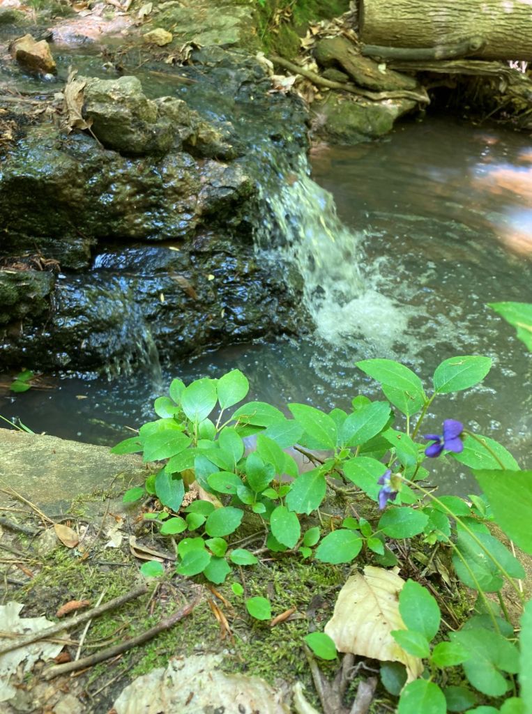
The trail was well-marked and led me through the beautiful woods, crossing several creeks (or maybe the same one multiple times) as I tramped along, feeling quite confident in myself. A small waterfall splashed a cheery tune into a pool of water. A garden gnome sheltered in a hollowed tree, and Ariel prepared to dive into a creek. Even the white fringe tree seemed to wave encouragingly to me. A mountain biker had come to an ignominious end at the bottom of a hill, but I was still in top form. I smiled inwardly as I passed a painted rock near a picnic table. Get lost? Naaahhh…


But at some point, the woods started mocking me. The trail twisted and turned until I lost my sense of direction. A sign on a tree ordered me to “do over.” Even the Singing Bridge was out of tune. I came to an intersection of three trails. Two had signs. One sign had the Palmetto Trail marker on it, so that’s the one I took. Wrong. I soon found myself paralleling the same trail I had just been on. Back to the intersection I went. I looked closely at each path and finally saw the familiar “¡”blaze on a tree down the path with no sign. I took this path and with the help of Google Maps set on hiking mode, I was back on track and soon at my car.


(Of course, at any time during my travails I could have just hiked over to the nearby gravel road and followed it back, but what’s the fun in that?)
For those of you who’d rather always know where you are, here’s a link to a map of the woods: https://www.newberrycounty.net/sites/default/files/uploads/lynchs_woods_kiosk_map_2.9.2021_final.pdf
Lynch’s Woods parking address: 7CF7+GJ Newberry, SC or 440 Wilson Rd, Newberry, SC 29108. Follow the road into the park and follow traffic signs. The Palmetto Trail kiosk is by the restrooms and picnic shelter.
Here ends our record-setting Palmetto Trail travels. Seven and a half passages in four days: my personal best. And if you’ve read all the way to the end of this lengthy accounting, congratulations! You’ve just set your own record! Now, get out there on the trail!


